Showing posts with label South Australia. Show all posts

Sunday, February 21, 2010

- The Nullarbor Plain -


Imagine a stretch of road over 1200kms long, linking the East to the West. With nothing more than a few conveniently placed roadhouses to help you continue on your way. The country side is remote, barren, almost waterless, windy with very little bushland in sections. If you haven't travelled the Nullarbor before this may only begin to paint the picture. However some find it extremely boring due to its length, but most find it a mix of boring and intriuge, due to the questions you find yourself asking while taking on this driving marathon. Like how can people live out here? or how does anything survive out here? What happens if we breakdown?


We set off from Ceduna, unsure how far we were going to drive on the first day. It was extremely windy and after 2 days on the beach all we really wanted was a shower! We called into Penong first, how ever the wind had turned it into a complete dustbowl and decided to push on a little further. Eventually calling into Nundroo where we fueled up and paid $2 for a shower to freshen up. We thought about stopping here but still the wind was kicking up some dust which would've made a very unpleasant afternoon.


(Nundroo Roadhouse.)


The Kilometers rolled passed and eventually we reached the signage of the treeless plain. The Nullarbor Plain, is the largest single sheet of limestone in the world covering over and area of 200,000 sq kms. It is pretty amazing, the sheer realisation that there is nothing else out there. It also hits you that if you break down, there is a LONG WAY to go to get fixed... But thankfully nothing happened and we enjoyed the wonder of crossing "The Plain".


Further along we called into lookouts of the Great Australian Bight, to get some photo's of the amazing coastline. However a few sites had been closed off as the erosion of the cliffs has been cutting away chunks of the coast all the way into the car parks!We arrived into the WA/SA Border village and pulled up for the night. Our last night in South Australia, we drove just over 600kms and looked forward to crossing over into home territory the following morning.


We rose early.. thinking we were still on SA time, fuelled up, went through the Quarantine check point and crossed into Western Australia. It's a weird feeling seeing "Welcome to Western Australia" and finally the realisation hits, we're coming home! We still had a long way to go and immediately the scenery started to change. We constantly passed road trains in both directions, travellers in their brightly coloured wicked vans, caravans and motor homes. The other thing that sticks in our mind is the road kill, poor kangaroos... too many were getting in the way of the massive trucks which are unable to stop! It was absolute carnage!

(The Border crossing...)


We eventually arrived in Norseman marking the end of the Eyre Highway, the end of the drive across the Nullarbor. We were still making good time and decided to drive the rest of the way into Esperance! That's a total 950kms in one day!!


Saturday, February 20, 2010

- The Eyre Penninsula -

Awaking in Port Pirie we made plans to tour around the Eyre Peninsula, having myself been there before and loved it, i really wanted to show Bren around the area. Best known for its remoteness, oysters and alternate route to parts of the Nullabor drive, it is well worth a look.


We began the journey passing through Port Augusta, the gateway to the centre, the west and the east. But apart from all this opportunity when you get there, there really isn't much else to Port Augusta other than being outback, and a mining port. we continued onto Whyalla, a windy mining town on the eastern coast of the Peninsula. here we caught up with an old friend of mine, Belinda, who i met on my travels 5ish years ago. It was great catching up and eventually became a BBQ and Beers evening.


(View from Whyalla lookout.)

The next day we said our goodbyes and continued down the coast calling into the little seaside towns. We eventually pulled into Tumby Bay which is quite a contrast to Whyalla, with a sweeping bay, beautiful white sandy beach, and a excellent jetty for fishing. We set up camp earlier than most days and set off for a fish when the tide was right... few hours later, with a few nibbles and unfortunately no fish to speak of, we called it quits. Bugger guess, I'll have to change the menu for tonight!

All packed up the following morning, we called into the biggest town on the peninsula, Port Lincoln. Known as a fishing port there was plenty to look at, we fishing vessels returning with their catch. We enjoyed a coffee and picked up some more information before heading out to the fish market to pick up a couple of fillets.... seeing as though we could catch a thing the night before! While in Port Lincoln many of the adventurous also pluck up the courage to go Great White Shark cage diving of the near by islands, which i would love to do someday, however it is quite expensive... so i wasn't going to be on this trip!

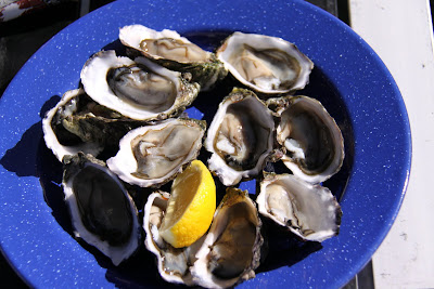
The road from Port Lincoln to Coffin Bay links the east to the west of the Peninsula. We pulled up in Coffin Bay for lunch while overlooking the beautiful bay. As you call into the town you can see how the Oysters are farmed, encased in baskets and hung on racks in the shallow water. We also bought some local Coffin Bay oysters, which was hard not to over indulge as they're are so cheap here compared to back home! Our plan was to camp the night in Coffin Bay National Park, however it was getting later in the day and the trip out would involve a mission of 4wding etc. We decided to push on to Elliston, further up the west coast. Coffin Bay also marked where the car clicked over to 400,000km on the clock!! My god, what an effort and still going strong!!


Once all step up for the evening in Elliston, i cooked up a glorious local feed, with the fish fillets and oysters we have purchased during the days travels! Yummooo!


(Bren having fun on the Elliston Coastal Sculptures.)

This stretch of coast would have to be my favourite of the Eyre Peninsula. The rugged coastline has claimed many ships, and then the sheltered bays provide quaint little fishing villages and the tourists love it! We spent the next day exploring, doing scenic drives. Talia caves were impressive with the force of the southern ocean carving out hollows in the limestone. Another highlight was the Murphy's Haystacks. Where a series of Rocks have been moulded over millions of years of wind erosion, making for some impressive photo's! Not far from the Haystacks we pulled up for lunch at a beautiful beach called Sceale Bay. The colour of the water was just breath taking!


(Murphy's Haystacks.)

That afternoon we completed the scenic drive on the headland near Streaky Bay. Which offered further glimpses of spectacular coastline. We we planning on staying in Streaky however we found out about this perfect little spot, not much further north and it was free. Free only due to a current land dispute with neighbouring landowners, but brilliant for us... when we arrived we were a little unsure as most of the parking area was taken up by motor homes... was there room for us??We spoke to one of the "local" travellers and found out we could camp under the beach shelters on the Beach!! Fantastic! It was like a dream, we set up camp under a huge shaded shelter only meters from the waters edge... it was amazing! Then and there we decided on another night.. after all is was FREE!

(Lookout near Streaky Bay!)


(Our camp and view under the beach hut, Perlubie Beach.)

The whole next day was spent walking along the long white sandy beach, swimming when we got a little hot, reading in the shade when we got too burnt and enjoying a beer as the sun went down over the ocean! What a way to end our trip around the Eyre Peninsula as the following day we were into Ceduna for supplies and embark on the journey across the Nullabor back to the west!


Monday, February 15, 2010

- The Murray River & The Barossa Valley -


The Murray River begins in the Australian Alps carving its way through 3 states ending in South Australia, that's a total of 2756 km! Its an amazing river and not knowing enough of its history encouraged us to get our Murray River Experience. We decided on the small township of Mannum to visit as it was the birth place of the iconic paddle steamers that transformed the Murray into a virtual river Highway back in the 1850's. The history of the region is amazing with dramatic floods, engineering marvels and typical Australian outback hardships of the time. In more recent times the draw card to the river is the holiday option of hiring out your own houseboat.


When we arrived it seemed like any outback town lining the banks of the river, however the longer we spent in Mannum we were immersed into the unique style of the region. The Paddle steamers are now a thing of the past, however the local historical society have rebuilt PS Marion to her formal glory, built in 1897 she is the last remaining wood fueled paddle steamers. We took a look around the boat and they truly are like no other, the powerhouse in the middle burning the wood to build up the steam to rotate the massive paddles on either side of the boat through the water.


(The Paddle Steamer Marion.)

The towns all along the river use the local transport which is by ferry, they're free and were well used by us when we took a drive out along the banks to some outlying towns. The dramatic cliffs carved by the water over time were a constant reminder that the river was once a lot bigger than it is today. We also took a tour on a little boat and it brought home the fact that this river is in fact in a bit of trouble. The water level has dropped over 2meters in the last 3 years with over extraction being the main cause, and that between the 3 states the river runs through, they're not using equal amounts or allowing enough water to flow downstream. This is resulting in many changes evident to us during our short stay effecting not only all those who use the river, the river itself is showing signs of stress. So without getting into a political story, we recommend if your travelling through, stop in and see the Murray River Region and help out the locals. The river is their lively hood and if the river continues to be exploited the way it is, the unique way of life maybe lost for good.


(Ferry crossing the river)

(Murray Princess)

After a interesting stay of 2 days in Mannum, we headed off towards Adelaide. Not before stopping in Birdwood to visit the National Motor Museum. It was an amazing showcase of cars that had Bren excited at every turn, everything from racing to vintage, to Eco friendly, to the outback feats made by hardy trucks and hardy Australians.
Adelaide is a nice city,and being a Saturday we had a look around the main shopping malls and then out to the local markets for a look around. There doesn't however seem to be a lot of appeal to Adelaide. Yes the beaches are nice, which we checked out on a drive out to see Port Adelaide. the main attraction for most is the festivals which occur there, however we were a few weeks to early and were more interested in enjoying the wine at the Barossa Valley. So after a Day exploring the city and they coast we headed back out to the Barossa, camping the night on its outskirts at the tiny town of Williamstown.
The Next day being Valentines Day, seemed like a perfect day to visit and sample the local drop. But where to begin?? There were so many to choose from, In the end we decided to go to the ones we knew or liked the look of and we'd call in... we were a little early at the Jacobs Creek Winery, so we enjoyed a coffee. However come the next winery we visited we got right into the swing of things. We called into Chateau Tanunda, built like a castle on sprawling grounds surrounded by rows of vines its hard not to want to spoil yourself! We sampled a few whites and bought a bottle for later and then it was onto the next! We went to the likes of Yalumba, Cockatoo Ridge and eventually it was lunch time and we called into this quaint little building home to Charles Melton Wines. We sampled the signature reds, and ate a glorious lunch on the Veranda it was beautiful! And afterwards bought a few bottles to send back to Perth!


(At Chateau Tanunda. Barossa.)


(Yummy Lunch!)

We then decided it would be best not to spend too long in the Barossa, for fear of draining the bank account and headed north west passing through the little town of Freeling made famous for the TV series McLeod's Daughters. Eventually we arrived in the baron town of Port Pirie and camped for the night!! What a day and so glad to know that we'll have special bottled memories of it waiting for us when we get home!


Friday, February 12, 2010

- A step into South Australia -


Crossing the border into South Australia was marked by a single sign, which we would've missed if it wasn't for the picture of vivid colours. against the dry country. Mount Gambier our first destination in South Australia, is like the diamond in the rough... its name sake arises on the horizon and is created by volcanic activity many millions of years ago. Also throughout the region several craters and sinkholes make up a unique draw card to the town. Most famous of these is the Blue Lake. In the summer, the lake takes on a vibrant blue colour which is just amazing to see.


The sinkholes were also spectacular, created by the roof of a cave collapsing in. One sinkhole has been turned into a display garden and just has to be seen to believed. A staircase takes you into the base for a better view and the gardens are amazing...


(Sinkhole garden.)


We continued along the limestone coast calling into the seaside towns for a look. Eventually we were amongst what is known as The Coorong, a fragile stretch of coastline, with salt lakes, bird life and wetlands. We stopped to learn a little about the history of the area, learning that in 1850's the Chinese travelled from Adelaide en route to Victoria during the gold rush. Passing through the area in search of water. Once they located water they built a well and carved a slab of sandstone out of the ground for the final lid.... it was amazing what they achieved. The lid weighs about 1,100kgs and they had to move it 900m and then lift it into position.


(Big Crayfish,Kingston.)

(A view at Robe.)


(Chinaman's Well, note the lid.)


We drove further long the Coorong, and eventually made our camp amongst the dunes over looking one of the salt lakes. The sunset was amazing, marking another wonderful day exploring the countryside.


(Sunset over the Coorong.)